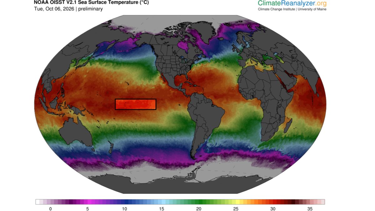
Sea surface temperatures in the central Pacific Ocean climbed to 31.2 degrees Celsius (88.2 degrees Fahrenheit) this month, the highest reading ever recorded for that region and 1.8 degrees above the previous record set in 2015, according to data from the National Oceanic and Atmospheric Administration.
The reading, taken from a network of moored buoys and satellite sensors stretching from Hawaii to the International Date Line, marks the first time the central Pacific has crossed the 31-degree threshold since continuous monitoring began in 1979. NOAA scientists say the anomaly is concentrated in a region that has historically been cooler than the eastern Pacific, where traditional El Niño events form.
That geographic shift is what concerns researchers. Classic El Niño events draw their energy from warming off the coast of Peru and Ecuador, but the current pattern is building thousands of miles to the west. Climate modeler Dr. Wei Zhang of the Scripps Institution of Oceanography said the setup does not match any of the six major El Niño events recorded since 1980.
"We are watching the ocean do something that our historical records do not contain an analog for," Zhang said. "The warm pool is not just larger, it has migrated. That changes where the atmosphere will respond."
El Niño patterns typically shift global weather by altering the jet stream. A central Pacific warm pool tends to push the jet stream farther north, which can mean heavier rain across California and the southern United States, drought in Australia and Indonesia, and weaker Atlantic hurricane seasons. The 2015-2016 El Niño, which formed in a similar but less extreme position, contributed to a global coral bleaching event that killed corals across 70 percent of the world's tropical reefs.
Australia's Bureau of Meteorology has already issued a watch-level alert, noting that the Indian Ocean Dipole — a separate climate pattern that can amplify or dampen El Niño effects — is currently in a neutral phase and could tilt either direction by December.
The warm water sits below a region where trade winds have weakened by 15 percent over the past three months, according to data from the TAO/TRITON buoy array. Weaker trade winds allow warm surface water to pile up in the central Pacific rather than being pushed west toward Indonesia, a feedback loop that can sustain and intensify the pattern for months.
NOAA's Climate Prediction Center is scheduled to release its next monthly ENSO diagnostic discussion on November 14. Researchers say the next six weeks will determine whether the warm pool persists into the Northern Hemisphere winter, when its effects on global weather are strongest.